M7C Nav-Station: Plotter GPS Navigator Fishfinder
Nav-Station M7C chart plotter with integrated fishfinder and multiple features for safer navigation.
Description
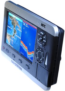
The Nav-Station M7C (combo) is a powerful plotter GPS multifunction navigator that integrates a fishfinder that can meet the most demanding demands.
The fishfinder operates with Digital Sounding technology on the double frequency 50/200 KHz with a power of 600W RMS, able to give you excellent performance on both shallow and deep water.
But the most appreciated feature of the M7C is that it is a real all-in-one that delivers exhilarating performance over a wide range of features. In fact, optionally you can integrate it with an AIS module to monitor all the boats identified in this system. It can also be equipped with a camera to monitor the transom or engine compartment, or it can be interfaced with an autopilot or various repeater instruments.
Of course, the choice of the LCD was not neglected, which is particularly bright and sharp thanks to its high resolution (800 x 480 pixels).
Another interesting feature is the bracket ?Quick Disconnect? that thanks to its quick release, helps us to take the plotter to a safe place.
Prices
060-3220
Nav-Station M7C - without transducer
988,00€Weight: 2.5 kg; Dimensions: 39 x 22 x 11.5 cm060-3230
Nav-Station M7C - with Trasd. Stern P58
1.086,00€Weight: 4 kg; Dimensions: 41 x 26 x 23 cm060-3231
Nav-Station M7C - with Trasd. Stern P58 + MW M017
1.391,00€Weight: 4 kg; Dimensions: 41 x 26 x 23 cm
Prerogative
- Integrated fishfinder with digital sounding technology
- Full modularity: AIS, camera, etc.
- Max Cartography by C-Map by Jeppesen
- High-brightness HD WVGA display
- Satellite Background
- Check-Route Security System
- Anti-Collision Guardian System
- All Around Ergonomic Controls
- Quick Disconnect Swivel Bracket
- Made in Italy
Specifications
| Screen | 7" LCD - TFT Color 600Cd/sqm Visible Under Sunlight |
| Definition | WVGA 800 x 480 pixels |
| Construction | IP56 (splashproof) |
| Cartography | SD-Card Max - Worldwide Background with Satellite Display up to 2 mn scales |
| User Points | 10000 |
| Routes | 50 to 51 Waypoints |
| GPS | With Integrated WAAS System |
| Depth | On models with Integrated Fishfinder |
| FishFinder | Integrated with all FishFinder Features, 600 W RMS, 50/200 KHz |
| AIS | All information via AIS receiver |
| Camera | 1 Input |
| Interface | 5 NMEA/FishFinder ports |
| External Memories | Via SD card |
| Power supply | 10 - 35 Vdc - 16 W |
| Dimensions | 166h x 256 x 96,5 mm - Weight 1,3 Kg |
| More Carats. | Check-Route, Collision Avoidance System Guardian, GoTo Self-Diagnostic |
Equipment
- Internal GPS
- Power supply cable/interface with fuse
- Quick disconnect" bracket
- Protective cover
- Jigsaw for flush-mounted installation
- Aesthetic finishing frame for when not recessed
- Models 060-3230 and 060-3231 are supplied complete with aft mount transducer
- The model 060-3231 is also supplied complete with Mega Wide Max M017 cartridge that covers the entire Mediterranean in the most minute details.
Accessories
030-1000
SevenStar 2RxPRO AIS receiver
376,00€030-3050
Vesper XB-6000 - AIS Transponder Class B Blackbox
732,00€030-3100
Vesper XB-8000 - AIS Transponder Class B Blackbox
976,00€061-1506
Quick release bracket for "M" series
117,00€061-1510
External GPS Nav-Fix Antenna for M-Series (TNC connector)
101,00€061-1530
Cable Alim./Interface 8 Pin - Nav-Station 5/6/11"
38,00€061-2080
P58 Poppa 500 W transducer shredder. - M Series
122,00€061-2081
Tritrasd. P66 High Speed 500 W stern - M Series
243,00€062-6400
C-Map SD Card Max Local
182,00€062-6500
C-Map SD Card Max Wide
279,00€062-6600
C-Map SD Card Max MegaWide
328,00€254-1020
IRIS IM-DND-60L Mini IR Camera - Wood
598,00€254-1030
IRIS IM-DND-60S Mini IR Camera - Carbon Fiber
586,00€254-1110
IRIS IM-DND-55 Mini IR-Chrome Recessed Camera
622,00€254-1210
IRIS IM-DND-80 IR Zoom/Focus Variable Camera
1.122,00€254-1410
IRIS IM-ERC-02 IR Camera Engine Room
415,00€254-1420
IRIS IM-GPC-20 Economical IR Camera
190,00€254-1430
IRIS IM-GPC-20R Economical IR Mirror Camera
229,00€254-1510
IRIS IM-RDC-01 Wireless Camera and Receiver
1.098,00€254-2010
IRIS IM-PTZ-16 Control Camera
3.392,00€254-2110
IRIS IM-PTZ-16T-9-L Thermal Camera - 9Hz 384x268
10.126,00€254-2120
IRIS IM-PTZ-16T-25-H Thermal Camera - 25Hz 640x480
12.566,00€
Downloads
Brochure Italian Nav-Station News 2010
- Date
- Format: Pdf
- Size: 0.2 Mb
Italian Nav-Station Manual M5, M7, M5C ,M7C
- Date
- Format: Pdf
- Size: 1.4 Mb
Procedure for Upgrading Nav-Station Software M-Series
- Date
- Format: Pdf
- Size: 0.1 Mb
Upgrade software for Nav-Station M7/M7C 13-06-12 163001R
- Date
- Format: Zip
- Size: 46,8 Mb
Upgrade software for Nav-Station M7/M7C 14-01-14 163200R
- Date
- Format: Zip
- Size: 46.6 Mb