Nautical GPS

The Nautical GPS, integrates the GPS, a nautical cartography and other sensors, to provide a variety of useful data for navigation.

The History of Nautical GPS and Electronic Nautical Cartography

Il primo chartplotter di C-Map anno 1985
The first chartplotter of C-Map year 1985

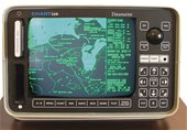
Nautical GPS, also called marine GPS or marine navigator, but also called in nautical jargon as chartplotter or plotter, is an essential element to help navigation.

Nautical GPS is a technology born entirely in Italy, many years before the first road navigator.

In 1983 Fosco Bianchetti and Giuseppe Carnevali were commissioned to build the first marine navigator in history to be installed on a mega yacht of an Arab Emir.
At that time there was the loran as a positioning tool and there were already some monitors that tracked the path of the boat, but not overlapping with a cartography.
This implementation was not easy because the processors of the time were not suitable to manipulate graphics and also the available memory was very limited. But a series of optimizations both from the hardware and software point of view, allowed the 2 engineers to complete this great undertaking, even if with a really primitive cartography and on a cathode ray tube monitor with green phosphors.

Subsequently, the two engineers aware of the commercial potential of their invention, in 1984 produced the first chartplotters for commercial purposes by founding the company Navionic (without the final "s").

In 1985 two different points of view divided the two engineers, Mr. Bianchetti believed that a real commercial breakthrough could only be achieved by saving on hardware costs and this would also slow down the entry of formidable competitors in this market, while Mr. Carnevali believed that satisfactory results had been achieved and that however this technology for some years would be reserved for a small niche market.
So Eng. Bianchetti founded the C-Map, while Eng. Carnevali founded Navionics.

In the following years, the market proved Mr. Bianchetti right, in fact there followed a rapid expansion of the marketing of the plotter and then the economisation of the hardware gave its results. In addition, Mr. Bianchetti, in some way the true technical creator of the first Nautical GPS in history (while Mr. Carnevali was mainly in charge of commercial relations), could count not only on his know-how but also on that of valid collaborators, some of whom were already involved in the first projects.
Carnevali also had his satisfaction, in fact he managed to sell the entire lot of plotters built with first-generation hardware, confirming that his theory was also correct.

Subsequently, both C-Map and Navionics dedicated their efforts to ensuring that other manufacturers used their own cartography and over time increasingly spread as manufacturers of nautical electronic cartography and not hardware (plotters).

In 2007 C-Map was acquired by Jeppesen (of the Boeing group) and its trade name became C-Map by Jeppesen.

Today, in addition to being many manufacturers of nautical GPS, there are also several manufacturers of cartography, but even today the cartographies of C-Map by Jeppesen and Navionics, are by far the most widespread in the world and according to almost all experts the best.

Nautical GPS Features

Nautical GPS Today

Today, nautical GPS is often understood as an on-board computer, i.e. a central unit to which several sensors or mechanical aids (such as an autopilot) are connected and which are controlled by the same unit.

So the nautical GPS can now show an infinity of data and command a set of features until it lends itself to be the central unit in nautical domotics.

But here we want to analyze the "pure" functionalities, that is all those operations that once could be carried out only with the classic nautical charts.

The main information provided

Nautical GPS increases the ability to provide information depending on the navigation status:

Boat stops

  • Possibility to monitor your position on the map
  • Verify the distance to the target or to danger areas
  • If we have interfaced it to appropriate modules, we can collect many other data, for example if it is installed AIS will display the boats nearby, will show instead the weather information of the area if it is installed a weather module.

Boat in motion, we'll have more:

  • The ability to display speed and direction

GoTo Set, we'll have more:

  • The distance, the route and the estimated time to reach our destination
  • It will inform about any off-course and necessary corrections

Graphic information

More and more graphic information is provided by a nautical GPS and is closely dependent on the electronic cartography used.

3 are the most common graphic display modes:

  • Plan 2D, is information often taken from the databases of the official hydrographic institutes (especially the map C-Map), is the best view from a safety point of view because the data are official, is presented in the way in which man has always consulted a map and the surface of the sea is physically projected as a normal plan 2D.
  • 3D, only present in certain cartographies, helps as an alternative visualization of 2D, but the information is often of low quality and perspective vision can lead to erroneous considerations in navigation, especially in maneuvers. It is instead useful in fishing, where at a glance, you have a good perception of the seabed below.
  • Satellite, for similar considerations expressed for the 3D, this too is poorly suited to navigation and especially to maneuvers. However, satellite visualization is exemplary in determining in advance the prerogatives of the destination location of our trip, such as determining if we like that location from the point of view of landscape.

7 are the most important graphic symbols that can be displayed:

  • Position of the vessel detected by an icon
  • Heading vector, direction line in front of the bow
  • Mark, also these marked by an icon
  • Route, the various icons that make up the route are shown, joined together by a line.
  • Bathymetric, distinguished by a line and often by different background colors
  • Port services also depicted with a distinctive icon
  • Danger areas, some maps well distinguish with special graphics the various randomness of danger

Main numerical data

  • Lat/Lon, stands for Latitude/Longitude
  • Date and time
  • GPS satellites in use
  • VDOP Vertical Dilution Of Precision
  • HDOP Horizontal Dilution Of Precision
  • PTL Partial Trip Log
  • TTL Total Trip Log
  • SOG Speed Over Ground
  • COG Course Over Ground
  • DST Distance To Target
  • BRG BeaRinG
  • TTG Time To Go
  • ETA Estimated Time of Arrival
  • VMG Velocity Made Good
  • XTE Cross Track Error
  • STR STeeRing

Nautical GPS Regulations

When is required

For recreational craft authorised to navigate beyond 12 miles, a radio-positioning device is mandatory. This means that even a GPS capable of showing only latitude and longitude would be sufficient.

However, on these classes of boats it is unthinkable not to install an instrument as useful as a real nautical GPS, which also complies with the regulations.

The mandatory nature of charts

The provision on board of a nautical GPS with electronic cartography, does not absolve in the pleasure craft to the need to keep on board the nautical charts (those of chart) of the navigation area.

In other words, nautical GPS cannot replace the traditional charts on board, which must always be the first reference and the captain is required to know the practice of traditional charting.

While this may be different on ships subject to GMDSS, where an ECDIS-certified nautical GPS with ECDIS-certified mapping may replace traditional nautical charts.