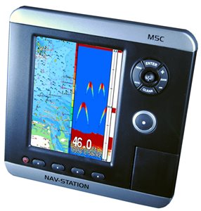
M5C Nav-Station: multifunction GPS plotter
Multifunction navigation system M5C with fishfinder, safety system Check-Route, electronic marine cartography C-Map.
Description
The Nav-Station M5C with integrated GPS, has been specially designed for small boats that demand all the functions in a single and compact instrument, without sacrificing anything in terms of performance and functionality.
In fact, the M5C integrates the functions of plotter and fishfinder, you can also interface it with various optional modules such as AIS, autopilot or other repeaters.
The fishfinder operates with Digital Sounding technology on the double frequency 50/200 KHz and with a power of 600W RMS, able to give excellent performance on both shallow and deep water.
On the right side appear new and original commands, which in addition to offering a valuable aesthetic sense, help a lot in the settings of the various features, without forcing the user to search elsewhere for the right button?
The bracket has also been redesigned to ensure immediate attachment of the plotter.
The user can also enjoy the countless details of the Max by Jeppesen cartography, leader in marine electronic cartography and appreciated by all professionals for better data reliability.
Prices
060-3120
Nav-Station M5C - without transducer
598,00€Weight: 2 kg; Dimensions: 35 x 22 x 11.5 cm060-3130
Nav-Station M5C - with Trasd. Stern P58
683,00€Weight: 3.5 kg; Dimensions: 41 x 26 x 23 cm060-3131
Nav-Station M5C - with Trasd. Stern P58 + MW M017
1.013,00€Weight: 3.5 kg; Dimensions: 41 x 26 x 23 cm
Prerogative
- Integrated fish finder with digital sounding technology
- Max Cartography by C-Map by Jeppesen
- Samsung LTG500QV display
- Satellite Background
- Check-Route Security System
- Anti-Collision Guardian System
- All Around Ergonomic Controls
- Quick Disconnect Swivel Bracket
- Made in Italy
Specifications
| Screen | LCD 5" - TFT Color 450Cd/sqm Visible Under Sunlight |
| Definition | WVGA 320 x 240 pixels |
| Construction | IP56 (splashproof) |
| Cartography | SD-Card Max - Worldwide Background with Satellite Display up to 2 mn scales |
| User Points | 500 |
| Routes | 25 to 51 Waypoints |
| GPS | With Integrated WAAS System |
| Depth | On models with Integrated Fishfinder |
| FishFinder | Integrated with all FishFinder Features, 600 W RMS, 50/200 KHz |
| AIS | All information via AIS receiver |
| Camera | No. |
| Interface | 3 NMEA/FishFinder ports |
| External Memories | Via SD card |
| Power supply | 10 - 35 Vdc - 14 W |
| Dimensions | 162h x 162 x 94 mm - Weight 700 gr. |
| More Carats. | Check-Route, Collision Avoidance System Guardian, GoTo Self-Diagnostic |
Equipment
- Internal GPS
- Quick disconnect" bracket for power supply/interface with fuse
- Protective cover
- Jigsaw for flush-mounted installation
- Aesthetic finishing frame for when not recessed
- Models 060-3130 and 060-3131 are supplied complete with aft mount transducer
- The model 060-3131 is also supplied complete with Mega Wide Max M017 cartridge that covers the entire Mediterranean in the most minute details.
Accessories
030-1000
SevenStar 2RxPRO AIS receiver
376,00€030-3050
Vesper XB-6000 - AIS Transponder Class B Blackbox
732,00€030-3100
Vesper XB-8000 - AIS Transponder Class B Blackbox
976,00€061-1506
Quick release bracket for "M" series
117,00€061-1510
External GPS Nav-Fix Antenna for M-Series (TNC connector)
101,00€061-2080
P58 Poppa 500 W transducer shredder. - M Series
122,00€061-2081
Tritrasd. P66 High Speed 500 W stern - M Series
243,00€062-6400
C-Map SD Card Max Local
182,00€062-6500
C-Map SD Card Max Wide
279,00€062-6600
C-Map SD Card Max MegaWide
328,00€