C-MAP C-Card M-EM-M017
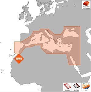
C-Card C-MAP code M-EM-M017, with map coverage of the entire Mediterranean, Max.
Description
Cartridge format C-Card tecnlogia Max, size Mega Wide, coverage area all over the Mediterranean.
Over the past 25 years, more than a million Internet users worldwide have relied on C-MAP electronic charts. C-MAP vector charts provide unparalleled navigation details and are compatible with the leading brands of nautical GPS. Unique navigation functions and value-added data make C-MAP solutions indispensable.
Prices
062-6304
C-Map Cartridge Max MegaWide M017 C-Card
328,00€Weight: 0.1 kg; Dimensions: 18 x 8.8 x 2.3 cm
Prices include VAT
Prerogative
- Dynamic NavAids - detailed and comprehensive information on navigation aid.
- Guardian Alarm - this function scans the area below your boat for obstacles, identifying a potential hazard along the way.
- Route-Check - an integration of the Guardian alarm function that increases safety by indicating any obstacles along the planned route.
- Harbour Charts - docking at an unknown port is no problem if you have thousands of detailed maps, including slipways, regulated areas, on-site services and other valuable navigational information.
- C-Marina Port database - includes detailed and exclusive information about ports more than any other navigation map available on the market. It indicates the timetables of the ports, the main contacts, the hotels and the nearest restaurants.
- Dynamic Tides and Currents - predicts the time, level, direction and intensity of currents and tides in real time.
- Photos and Diagrams - high-definition photos of marinas and ports. Display of significant navigation signals.
- Depth and Land Elevation - not only will you have the usual depth information, but you will also see various colors that will help you to more easily distinguish the different depths and altitudes. You can easily see your favorite angles and locations along the bottom for fishing or landmarks that indicate your location along the coast.
- Perspective View - an aerial view from the top of your navigation area.
- POIs - and Road Mapping - the largest database of services that will allow you to find everything you need (hotels, restaurants, petrol stations, shops, etc.).
- PC-Planner compatible - you can plan a route and save it on a user card for later use on your Chart Plotter.
Equipment
- Case