Seiwa SW700 GPS Cartographic
Seiwa SW700 chart plotter for boats, 800 x 480 pixels colour screen, optional fishfinder, radar or AIS.
Description
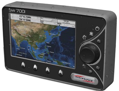
The new SW700 is a true example of what technology can do on boats today. Every single detail can be distinguished, thanks to a high-performance LCD display of the latest generation with 800 x 480 pixels.
Always ready for every user's request thanks to a powerful processor capable of giving an instantaneous display of the data.
The Seiwa SW700 can be fully integrated with various optional modules, such as the fishfinder, radar or AIS.
Prices
060-5230
Seiwa SW700i (Integrated GPS)
1.135,00€060-5234
Seiwa SW700e (external GPS)
1.232,00€
Prices include VAT
Prerogative
- Cartography Jeppesen Max
- 7" 800 x 480 Pixel LCD
- IP67 (Waterproof)
- Quick Disconnect Bracket
- Anti-Collision Guardian System
- Radar, Weather, Wind and AIS option.
Specifications
| Screen | 7" LCD - TFT Color 350Cd/sqm Visible Under Sunlight |
| Definition | WVGA 800 x 480 pixels |
| Construction | IP67 (Waterproof) |
| Cartography | SD-Card Max - Worldwide Background with Satellite Display up to 2 mn scales |
| User Points | 10000 |
| Routes | 50 to 51 Waypoints |
| GPS | with Integrated WAAS System |
| Depth | Depth and Graph with optional Active Transducer |
| FishFinder | All FishFinder features via Black-Box |
| AIS | All information via AIS receiver |
| Camera | 1 Input |
| Interface | 5 NMEA/FishFinder ports |
| External Memories | Via SD card |
| Power supply | 10 - 35 Vdc - 13 W |
| Dimensions | 154h x 244 x 109 mm - Weight 1,2 Kg |
| More Carats. | Collision avoidance system Guardian |
Equipment
Internal GPS for model 060-5230, External smart GPS for model 060-5234. Protective cover, power/interface cable and bracket.