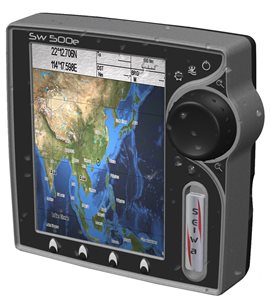
Seiwa SW500 GPS Nautical Cartographic
Marine Navigator Seiwa SW500 for boats, Background Satellite Cartographic preloaded, compatible with optional Box Fishfinder.
Description
Able to give the console of the boat that extra charm of technology, typical of every Seiwa instrument, but even more accentuated in this fascinating instrument with an elegant and technological design.
Remarkable performances that allow very fast response times without hesitation to every request of the user.
The multifunction SW500 can be fully integrated with various external modules (optional) that can also make it a valid fishfinder or AIS display center.
Prices
060-5030
Seiwa SW500i (Integrated GPS)
610,00€060-5034
Seiwa SW500e (external GPS)
647,00€
Prerogative
- Cartography Jeppesen Max
- 5" LCD 240 x 320 Pixel
- IP67 (Waterproof)
- Satellite Background
- Quick Disconnect Bracket
- Anti-Collision Guardian System, Weather
- Optional wind and AIS
Specifications
| Screen | LCD 5" - TFT Color 350Cd/sqm Visible Under Sunlight |
| Definition | 240 x 320 Pixels |
| Construction | IP67 (Waterproof) |
| Cartography | SD-Card Max - Worldwide Background with Satellite Display up to 2 mn scales |
| User Points | 5000 |
| Routes | 50 to 51 Waypoints |
| GPS | with Integrated WAAS System |
| Depth | Depth and Graph with optional Active Transducer |
| FishFinder | All FishFinder features via Black-Box |
| AIS | All information via AIS receiver |
| Camera | No. |
| Interface | 3 NMEA/FishFinder ports |
| External Memories | Via SD card |
| Power supply | 10 - 35 Vdc - 7 W |
| Dimensions | 151h x 154 x 85 mm - Weight 520 gr |
| More Carats. | Collision avoidance system Guardian |
Equipment
Internal GPS for model 060-5030, External smart GPS for model 060-5034. Protective cover, power/interface cable and bracket.